Posted by Notcot on May 16, 2010 in
In-Car Technology |
Average Rating: 3.5 / 5 (15 Reviews)
Manufacturer’s Description
|
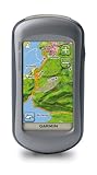
The Oregonâ„¢ 400T
Touch the great outdoors.
|

Compass |

Barometric
Altimeter |

Mapping routes |

Expandable memory |

Training centre |

Trip computer |

Waterproof |

Waypoints |
|
|

- Touch and go
Oregon’s revolutionary touchscreen interface puts every
feature at your fingertips. Just pick a function, press and go.
An integrated screen lock removes risk of accidental activation.
- Menu simplicity
An easy-to-use touchscreen menu makes navigating Oregon a breeze. Simply scroll through the bright, bold icons with a brush of your thumb, scan the options and tap to choose. Spend more time enjoying the outdoors and less searching for information.
- High-resolution display
A bright, sunlight-readable colour screen, with adjustable backlight, aids navigation in all conditions. Clear mapping and controls give you the tools to find your way back whether roaming the wilderness or strolling a country track.
- Built-in mapping
Oregon 400T’s built-in European topographic basemap, with street-level detail contains landscape features including lakes, rivers, cities, major roads, railways and coastlines.
- Store and expand
Oregon’s internal memory means you can save map data, trip information like routes and tracks and even photos. Plug in a microSD™ data card for additional storage and slot in marine, street map or topographic mapping to match your activity.
- Automatic routing
When it’s not guiding you on adventures by track or trail, Oregon can also handle the road. Enjoy turn-by-turn directions by plugging in optional TOPO GB or City Navigator mapping cards.
- 3D elevation view
Appreciate the surrounding terrain with Oregon’s 3D views. Visualise the contours on topographic maps to enjoy a better perspective of your elevation and understand your onward adventure.
- Geocaching and GPS games
Discover the buzzing world of geocaching or raise your game to
new heights. Oregon supports Geocaching.com GPX files so you
can download caches, terrain and location detail straight to the
unit. Built-in GPS games offer more ideas for your leisure.
- Image viewer
Use Oregon’s Picture Viewer to transfer and browse images on the unit. You might want to save a motivational photo to spur you on an outdoor challenge, save memorable excursion snaps or keep a visual reference of the next stage of the journey.
- High-sensitivity GPS receiver
Garmin mapping handhelds contain a high-sensitivity GPS receiver, designed for optimum view of the sky. Quickly and strongly lock onto a signal and benefit from improved tracking under trees and near tall buildings.
- Staying power
With 18 hours’ charge from just two AA batteries, you
can depend on Oregon to endure any outdoor activity –
whether going out and about for some fresh air or planning
a full-day’s excursion.
- Waterproof design
Waterproof to IPX7 standard, if you can brave the elements, Oregon can too. There’s no need to take cover in a downpour and no problem navigating on the water or across wetlands. The MicroSD card slot is inside the waterproof battery compartment too.
- Track Log
Save multiple points on your journey as a ‘Track Log’ for an accurate record of your route. Reverse the path to return to
your start point or share and review in Google Earth when
you get home.
- Route ahead
Plan and transfer new routes on your PC and send direct to Oregon. Or save an enjoyable journey to make a return trip. Wirelessly-enabled Oregon’s can share waypoints, routes,
tracks and geocaches unit-to-unit.
- Trail-plotting functions
Your GPS mapping handheld has ample memory to save and store route data. Whether a waypoint, favourite or location, save multiple locations on your unit and Garmin will guide
you straight there or make it part of a future route.
- On-board memory
There’s ample space onboard your Oregon to save key
routes, points or journey data. If you want to build up
a collection of favourite journeys, just slot in a MicroSD
data card for extra storage.
- Electronic compass
Ideal for manual navigation off the beaten track, a built-in electronic compass keeps you on course, however far you
stray from the path. It even gives bearing information when standing still. Seek out a saved waypoint and navigate easily
to a mapped position.
- Barometric altimeter
A built-in barometer tracks changes in atmospheric pressure to pinpoint your precise altitude. The altimeter screen plots elevation and profile. You can even plot barometric pressure over time to keep an eye on changing weather conditions.
- Environment information
Oregon is packed with essential data to boost your outdoor pursuits. With sun and moon information, tide tables and a hunt / fish calendar, get in the know about what’s going on and remain aware of your surroundings.
- Area calculation
Sum up the total area enclosed by a saved track to calculate the reach of a specified region. Surveying a property or evaluating an expanse of land? This useful tool will bring you the bigger picture.
- PC link-up
Oregon’s USB interface lets you sync it up to your PC to transfer maps and journey data.
Plan and review your routes and pick out key stops before you leave the house.
- Download routes and tracks
While it thrives on voyages of discovery, Oregon can also navigate routes recommended by others. Just download a track from a route sharing site and import to Oregon to retrace the adventure.
- Unit-to-unit transfer
The Oregon 300 and 400t let you sync up and transfer routes, tracks, points and caches wirelessly with other users. Share your adventures with friends or show them where to
find you. Sharing your Oregon data is easy – one tap and you’re away!
- Preloaded mapping
The three models within the Oregon series come with a selection of preloaded basemaps
Â
Â
|
- Garmin Oregon 400T Mapping Handheld GPS Receiver
- Waterproof
- USB and NMEA 0183 compatible interface
- Automatic routing (turn by turn routing on roads
- Electronic compass
Garmin Oregon 400t Handheld GPS with European Maps
Buy Now for £269.96
Tags: 400t, accidental activation, backlight, bright sunlight, card, City, colour screen, European, expandable memory, Garmin, gb, GPS, great outdoors, Handheld, information, internal memory, journey, landscape features, Mapping, Maps, memory, memory training, microSD, navigation, Oregon, Route, Slot, street level detail, street map, T Touch, topographic mapping, Touchscreen, touchscreen interface, track, trail oregon, Trip, trip computer, unit, Waterproof
The Oregon 400t is my first hand help GPS and I’m very impressed. I am quite happy navigating with map and compass but the Oregon saves quite a bit of time and is great when map reading is difficult – like when in a wood with no obvious features. The Oregon does support OS grid reference for location as well as Lat/Long – you do need to look through all the setup options, the manual doesn’t tell you all of the available options. Since I have OS maps of all the areas I am likely to use the GPS I don’t mind the quality of the base map – in fact I like it for being ‘clutter’ free. You can now get digitised OS maps for the Oregon – though only National Parks I think – but I personally can’t see the point.
Uploading waypoints and routes from a PC is simple, as is downloading track files of your travels. You may need something to convert .gpx files to other formats but such software is freely available. I you want to connect the GPS as a receiver for another application on a PC this may be more difficult – I couldn’t get the Oregon to talk to my old version of Memory-Map Navigator even using Garmin Spanner.
In use the Oregon has been fast to get a lock on satellites and has been very accurate – to within 10 meters. The touch screen is easy to use and I have not had any trouble reading the screen outside – even on bright winter days with the sun low in the sky. Battery life has also been very good – though I’m going to use rechargeables in future.
Overall a very useful navigational aid.
Rating: 5 / 5
This is the best handheld gps there is, true. But what no one tells you is the maps you can buy online and on sd card from ordanence survey, quo and memory map you can only use on your pc and cant download or use card in your gps. UNLESS its bought from garmin. The GB topo (at £107 if you shop around not the £150 garmin want for it) is a massive improvement on the so called topo map pre installed which has contour lines at 100m! Even that is nothing like even a 1:50000 OS map. The OS maps which garmin are starting to release are only covering national parks so far and at £160 each its a very expensive alternative to an £8 OS map.
I know smartphones and pda’s arent waterproof and spare battery is expensive but you have no problems with authoring limitations to use maps bought economically from OS, Quo or Memorymap
Rating: 2 / 5
The Garmin Oregon 400t is a very good hand held GPS unit. It has a very solid build quality and is packed full of great features including paperless geocaching. It is also very easy to use and the touch screen works very well. However the same quality cannot be said for the pre loaded mapping. Yes it does contain pre loaded topo maps for europe ,BUT they are nowhere nearly as detailed as the optional topo GB DVD and the hill contours are few and far between. Also if you intend to use this GPS as a sat nav the preloaded maps do not support “TURN BY TURN” mapping for which you need to purchase either the MAPSOURCE TOPO GB DVD or MAPSOURCE CITY NAVIGATOR DVD.The pre loaded SD cards may support TURN by TURN but I’m not sure.
Rating: 4 / 5
I have only used this device once so far and am pretty impressed with its capabilties.I am dissapointed that it has no grid reference ability for the u.k, as I bought it to locate ancient trees and these are done via the u.k grid system as apposed to n degree etc. I cant say too much as yet but will update this as and when I encounter issues, however, I do not think i will ever regret buying this over cheaper options either in the Garmin or other brand categories. As far as turn by turn support is concerned seems daft to be overly concerned with this like some people are, car sat nav is cheap these days and better off buying a product just for the car.
The reception is excellent in this device and works indoors and under heavy canopy which was my main reason as I spend much of my time in deep wooded terrain, but it is winter, lets see how it copes when the broadleaf forest is in full summer foliage!
Update-
having now had a good play with the device I can give some pros and cons to this device, I will start with the pros.
First thing Ive noticed is the ease in learning by trial and error how to use and fully realise ALL the functions within the device, I had no previous GPS knowledge but this was a piece of cake. if your new to this GPS world, buy this and you wont go wrong, a 5 year old could find thier way around the globe with this!
The reception is very good, and the detail of reception information usefull as for example GPS acuracy readouts, typical 29-40ft acuracy sometimes better sometimes worse.
I can state that there is no need to buy turn by turn road navigation maps, it does have a road nav lock and is more than adequate. Turns shown well in advance, and a bleep signaling ahead of a new turn a pink track indicating the route and overlayed ahead a white overlay indicating the turning path or roundabout/junction approach. You will find this much less anoying than that repetative voice of typical sat nav for vehicles!
Road navagation SORTED
Another usefull aid for me being an angler is the area measuring facility, i can now walk around the lake and get a reading of the acerage of the lake i am targeting! and enter waypoints of my favourite swims! essential on BIG waters.
defo buy the topo maps on the micro sd cards if your on walkabout, these maps are awsome, though could be more detailed in 20ft ranges as aposed to the bigger picture, but thats asking way more than is fair.
cons
overly hungry on batteries, be warned, get som nimh rechargeables! alkalines and lithiums will be swallowed whole like candy!
compatability with 3rd party maps nil, will cost garmin in the long run.
not a lot of negatives, i love my 400t its awsome and I will never be wothout a GPS device EVER again it has enhanced my view of my favourite places and my enjoyment and experiance of going to new places, awsome.
Rating: 4 / 5
A great piece of kit – new to the world of hand held GPS – it took me a few weeks to get used to it and all of its functions. A few tips
Get rechargable batteries (good one’s)
If in the Uk and using a map – set the GPS to WASS or normal and enter British Grid (under position Format ) the GPS will do the rest for this bit
Learn to use a map and compass – esp in the wilds – as the GPS may pack up.
Turn the relief shading off ( in strong sunlight )
I never bought any of the mapping stuff – too expensive for what you get -OS maps much better – and cheaper.
Have a play with the compass settings – and don’t forget to calibrate the compass after changing batteries / going to another country* (* you will also need to change postion format etc) seems complex, and it is – but spend a couple of hours each day and you will get used to it.
HOTFIX works great – insruction manual not good – join a GPS site for tips etc . Also down-load the latest softwear Garmin bring out –
I have read dozens of reviews on the Garmin 400t – my view is that this piece of kit is the best around –
I am off to Western Crete soon – armed with my GPS and a map and compass to explore the white mountains –
Buying off this site also saved me £100
Rating: 5 / 5