Posted by Notcot on May 30, 2010 in
Handhelds & PDAs Tags: Average, card, colour, Garmin, GMAP, GPS, Handheld, Mapping, microSD, microsd card, rating, Reviews
Posted by Notcot on May 16, 2010 in
In-Car Technology 
Average Rating: 3.5 / 5 (15 Reviews)
Manufacturer’s Description
|
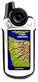
The Oregonâ„¢ 400T
Touch the great outdoors.
|

Compass |

Barometric
Altimeter |

Mapping routes |

Expandable memory |

Training centre |

Trip computer |

Waterproof |

Waypoints |
|
|

- Touch and go
Oregon’s revolutionary touchscreen interface puts every
feature at your fingertips. Just pick a function, press and go.
An integrated screen lock removes risk of accidental activation.
- Menu simplicity
An easy-to-use touchscreen menu makes navigating Oregon a breeze. Simply scroll through the bright, bold icons with a brush of your thumb, scan the options and tap to choose. Spend more time enjoying the outdoors and less searching for information.
- High-resolution display
A bright, sunlight-readable colour screen, with adjustable backlight, aids navigation in all conditions. Clear mapping and controls give you the tools to find your way back whether roaming the wilderness or strolling a country track.
- Built-in mapping
Oregon 400T’s built-in European topographic basemap, with street-level detail contains landscape features including lakes, rivers, cities, major roads, railways and coastlines.
- Store and expand
Oregon’s internal memory means you can save map data, trip information like routes and tracks and even photos. Plug in a microSD™ data card for additional storage and slot in marine, street map or topographic mapping to match your activity.
- Automatic routing
When it’s not guiding you on adventures by track or trail, Oregon can also handle the road. Enjoy turn-by-turn directions by plugging in optional TOPO GB or City Navigator mapping cards.
- 3D elevation view
Appreciate the surrounding terrain with Oregon’s 3D views. Visualise the contours on topographic maps to enjoy a better perspective of your elevation and understand your onward adventure.
- Geocaching and GPS games
Discover the buzzing world of geocaching or raise your game to
new heights. Oregon supports Geocaching.com GPX files so you
can download caches, terrain and location detail straight to the
unit. Built-in GPS games offer more ideas for your leisure.
- Image viewer
Use Oregon’s Picture Viewer to transfer and browse images on the unit. You might want to save a motivational photo to spur you on an outdoor challenge, save memorable excursion snaps or keep a visual reference of the next stage of the journey.
- High-sensitivity GPS receiver
Garmin mapping handhelds contain a high-sensitivity GPS receiver, designed for optimum view of the sky. Quickly and strongly lock onto a signal and benefit from improved tracking under trees and near tall buildings.
- Staying power
With 18 hours’ charge from just two AA batteries, you
can depend on Oregon to endure any outdoor activity –
whether going out and about for some fresh air or planning
a full-day’s excursion.
- Waterproof design
Waterproof to IPX7 standard, if you can brave the elements, Oregon can too. There’s no need to take cover in a downpour and no problem navigating on the water or across wetlands. The MicroSD card slot is inside the waterproof battery compartment too.
- Track Log
Save multiple points on your journey as a ‘Track Log’ for an accurate record of your route. Reverse the path to return to
your start point or share and review in Google Earth when
you get home.
- Route ahead
Plan and transfer new routes on your PC and send direct to Oregon. Or save an enjoyable journey to make a return trip. Wirelessly-enabled Oregon’s can share waypoints, routes,
tracks and geocaches unit-to-unit.
- Trail-plotting functions
Your GPS mapping handheld has ample memory to save and store route data. Whether a waypoint, favourite or location, save multiple locations on your unit and Garmin will guide
you straight there or make it part of a future route.
- On-board memory
There’s ample space onboard your Oregon to save key
routes, points or journey data. If you want to build up
a collection of favourite journeys, just slot in a MicroSD
data card for extra storage.
- Electronic compass
Ideal for manual navigation off the beaten track, a built-in electronic compass keeps you on course, however far you
stray from the path. It even gives bearing information when standing still. Seek out a saved waypoint and navigate easily
to a mapped position.
- Barometric altimeter
A built-in barometer tracks changes in atmospheric pressure to pinpoint your precise altitude. The altimeter screen plots elevation and profile. You can even plot barometric pressure over time to keep an eye on changing weather conditions.
- Environment information
Oregon is packed with essential data to boost your outdoor pursuits. With sun and moon information, tide tables and a hunt / fish calendar, get in the know about what’s going on and remain aware of your surroundings.
- Area calculation
Sum up the total area enclosed by a saved track to calculate the reach of a specified region. Surveying a property or evaluating an expanse of land? This useful tool will bring you the bigger picture.
- PC link-up
Oregon’s USB interface lets you sync it up to your PC to transfer maps and journey data.
Plan and review your routes and pick out key stops before you leave the house.
- Download routes and tracks
While it thrives on voyages of discovery, Oregon can also navigate routes recommended by others. Just download a track from a route sharing site and import to Oregon to retrace the adventure.
- Unit-to-unit transfer
The Oregon 300 and 400t let you sync up and transfer routes, tracks, points and caches wirelessly with other users. Share your adventures with friends or show them where to
find you. Sharing your Oregon data is easy – one tap and you’re away!
- Preloaded mapping
The three models within the Oregon series come with a selection of preloaded basemaps
Â
Â
|
- Garmin Oregon 400T Mapping Handheld GPS Receiver
- Waterproof
- USB and NMEA 0183 compatible interface
- Automatic routing (turn by turn routing on roads
- Electronic compass
Garmin Oregon 400t Handheld GPS with European Maps
Buy Now for £269.96
Tags: 400t, accidental activation, backlight, bright sunlight, card, City, colour screen, European, expandable memory, Garmin, gb, GPS, great outdoors, Handheld, information, internal memory, journey, landscape features, Mapping, Maps, memory, memory training, microSD, navigation, Oregon, Route, Slot, street level detail, street map, T Touch, topographic mapping, Touchscreen, touchscreen interface, track, trail oregon, Trip, trip computer, unit, Waterproof
Posted by Notcot on Apr 23, 2010 in
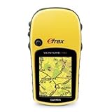
Handhelds & PDAs Tags: Average, eTrex, etrex venture, Garmin, garmin etrex, garmin etrex venture, GPS, gps navigator, Handheld, Navigator, rating, Reviews, Venture
Posted by Notcot on Apr 16, 2010 in
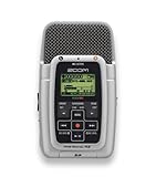
Home Cinema & Video Tags: Average, capacity, card, DescriptionZOOM, Handheld, Handy, Handy Recorder, High, high capacity, memory, memory card, Product, rating, RECORDER, Reviews, zoom
Posted by Notcot on Apr 15, 2010 in
Handhelds & PDAs 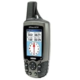
Average Rating: 4.5 / 5 (23 Reviews)
- High-sensitivity WAAS-capable GPS receiver by Si
- Built-in quad-helix receiving antenna with remot
- Display: 38.1mm x 56mm 256-colour transflective
- Sensors: Electronic compass displays accurate he
- LED backlit display and keypad
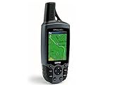
Garmin GMAP 60CSx Handheld
Buy Now for £210.00
Tags: 256 colour, 60CSx, antenna, Average, backlit display, colour, Display, Electronic, electronic compass, Garmin, GMAP, GPS, gps receiver, Handheld, heLED, helix, high sensitivity, rating, receiver, receiving, remotDisplay, Reviews, SiBuilt-in, WAAS-capable
Posted by Notcot on Mar 27, 2010 in
Electronics 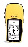
- The eTrex H GPS from Garmin guarantees simple and reliable satellite navigation service.The12 channel receiver quickly picks up satellite signals and holds ontothem, even in extreme conditions. It has an internal antenna, so itstill fits easily in your pocket. The eTrex H memorises up to 10 tracks and 1,536 points of interest, making it the ideal hiking companion. Internal menulanguages: French, English, Spanish, German, Italian, Swedish, Danish, Norwegian,Portuguese, Dutch, Finnish, Polish, C
- zech, Hungarian, Croatian, Greek, Turkish Â
- GARMIN eTrex H Outdoor GPS Handheld GPS GPS & Sat Nav
- Handheld GPS
Garmin eTrex H Handheld GPS Navigator
Tags: antenna, channel, channel receiver, companion, croatian, english spanish, eTrex, extreme conditions, french english, Garmin, garmin etrex, gps garmin, gps garmin etrex, gps navigator, H GPS, H Handheld, Handheld, handheld gps, hiking, interest, Internal, internal antenna, itstill, navigation, navigation service, Navigator, ontothem, pocket, points of interest, receiver, satellite, satellite navigation, satellite signals, service